A GREAT LEAP FORWARD FOR AVIATION SAFETY
james sparling
by Roger Rapoport
After a year of tragic, unexplained and mysterious calamities, commercial aviation is beginning 2015 with a major breakthrough designed to keep flights out of harm’s way. This year, for the first time in aviation history, a major global airline is beginning to implement a long range transoceanic system that could revolutionize how flight crews avoid dangerous storms such as the one that triggered the crash of Air France 447 in 2009 taking the lives of 228 people.
If this satellite based weather detection and forecasting system had been available to pilots on Air Asia 8501, pilots on that flight would have been able to avoid the convective storm that may have been a contributing factor in this December 2014 tragedy that left 162 people dead.
“Not only is it likely to give air carriers a competitive advantage, it could potentially lower pilot workloads, reduce fuel costs and help them avoid storms that were major contributing factors in the Air France 447 accident and several crashes last year.”
Studied by meteorologists, aeronautical engineers, the FAA, and airlines over the past decade, this new system, detailed here for the first time, is a satellite-based weather detection and forecasting model that can give pilots at least a 500 mile head start on deviating around devastating convective storm systems. The details are delivered on the crew’s electronic flight bag – a tablet computer mounted in the cockpit. Once in place this system can help flight crews avoid potentially dangerous weather systems that produce lighting, extreme turbulence, dangerous updrafts, downdrafts and icing.
Not only is it likely to give air carriers a competitive advantage, it could potentially lower pilot workloads, reduce fuel costs and help them avoid storms that were major contributing factors in the Air France 447 accident and several crashes last year.
The technology behind this project was originally created in 2006 and tested in a a study organized by the Federal Aviation Agency, the National Center for Atmospheric Research in Boulder, Colorado and United Airlines on long oceanic flights from San Francisco to Sydney. Unfortunately it had to wait nine years before a major carrier was able to implement it on an operational basis.
Last month Lufthansa, after a series of tests using an algorithm created by NCAR and licensed for commercial application through New Jersey’s Basic Commerce and Industries (BCI), confirmed that this “cloud top” product is effective in forecasting and avoiding storms beyond the reach of onboard radar used on all planes. They awarded a contract to BCI to provide this satellite-based product on its entire fleet, providing coverage for all regions of their flights by this summer. If it meets expectations, this new forecasting and storm avoidance system could possibly motivate other carriers to follow suit.
Planes flying overland in areas such as North America, Europe and Asia traditionally count on a reliable system of ground based radar to supplement onboard cockpit radar that has a range of up to 250 miles. This traditional network and related systems provides a real time picture that goes far beyond the storm fronts pilots can spot on their cockpit radar screens.
For example a pilot may see the leading edge of a storm but miss a secondary storm system tucked in behind. As veteran aviation accident investigator and pilot Shem Malmquist explains, “airborne weather radar is further limited in that it only will show ‘wet’ precipitation. That means that dry precipitation, like hail, snow, or ice crystals, just do not ‘paint’ at all, on the radar screen, or if they do, they show up in a very limited way.”
In addition, while the radar can show what’s out front, it is not able to create a critically needed picture of cloud top heights. This snapshot of the entire weather environment can best be pinned down with a combination of onboard radar arrays and satellites looking down on storm systems.
Understanding these cloud top heights is critical. For example a towering convective system might harbor a dangerous thunderstorm that could tear a plane apart. Even planes flying above or downwind of one of these dangerous storm can be rocked by severe turbulence. Powerful updrafts and downdrafts can potentially injure passengers. Ice, undetectable on cockpit radar systems, can occur in the vicinity of one of these systems, potentially threatening the flight in several ways.
A related problem, says Malmquist, is that sometimes precipitation will not be frozen even through the temperature of the water is already well below the freezing point. In effect it can be “stuck” in a liquid state down to -49 degrees fahrenheit. In this case the supercooled water turns into ice when it strikes the plane’s surface. Icing can also be a problem when the wing aerodynamically heats the air, momentarily melting frozen water only to have it refreeze on the surface of the plane.
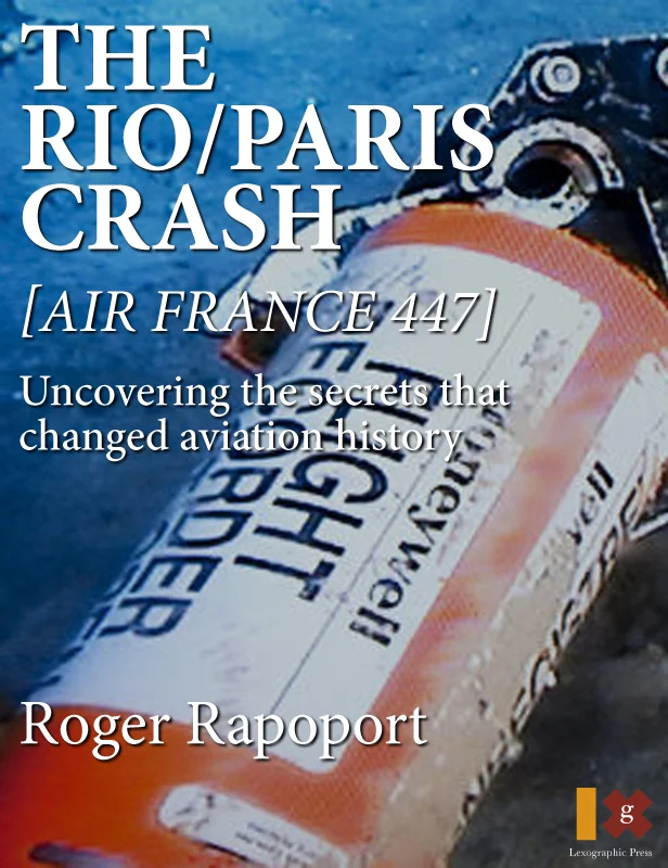
In the case of Air France 447 the plane hit a "shower" of frozen ice crystals that plugged up the pitot tubes normally providing critical airspeed information to the flight’s computers. Lack of reliable airspeed triggered a series of problems that led to a stall and crash. Avoiding this storm entirely would have eliminated the potential icing problem.
In 2006, Dr. Bruce Carmichael, director of NCAR’s Aviation Applications Program and Research Applications Laboratory found a solution with a viable cloud top product. He worked with a team of experts to give transoceanic pilots reliable information similar to what they now receive from land based radar that only reaches out about 200 miles from the coast. The original version tested with the FAA, streamed cloud top height information from a satellite to the plane’s ACARS electronic messaging system via a cockpit printer.
“The point was that pilots could take off with a comprehensive view of weather along their entire route of flight and then update 500 or more miles ahead,” says Carmichael’s colleague, project scientist Cathy Kessinger.
“That way they could avoid convective storms entirely,” adds one meteorologist who has studied the problem. “It’s the best of two worlds. You get better situational awareness from a satellite picture looking down at the towering cloud-tops from 60,000 miles vs. just looking ahead on the cockpit radar.”
Unfortunately, after initial tests proved successful, the 2006 system which could have been implemented in less than a year at a cost of $1 million a plane, was cancelled by the FAA due to funding issues. It was only resumed a few years ago as part of the FAA’s ‘Weather Technology In The Cockpit’ program. The FAA, in collaboration with NCAR, has recently completed initial testing of this new technology at its Atlantic City research facility. The federal agency is now moving toward an operational test on an American carrier that could be completed in 2016.
While a funding request for the next stage of the FAA study is being submitted, Lufthansa is moving ahead. The German carrier is taking advantage of existing onboard wifi currently used by passengers to stream data to pilots up front. Not only is the carrier planning to use the cloud top product on transoceanic flights, it also wants to implement it overland. In addition to forecasting and avoiding turbulence, the NCAR product is also useful in many countries that can’t afford comprehensive ground radar networks.
If Lufthansa’s program proves successful it would become a competitive model for other carriers to match. Beyond reducing pilot workload and helping flight crews avoid dangerous storms over the ocean and areas with poor radar coverage, it’s highly likely that more efficient flight planning will cut fuel costs by reducing the extent of weather deviations and improving the ability to fly at optimum altitudes.
John Clemes, former vice-president of the Air France 447 Families’ Association, whose brother Brad perished in the 2009 Airbus 330 accident, applauded this promising new technology: “If we can efficiently equip commercial aircraft with an effective means of avoiding major storms over the ocean, then we can hope it would be a significant step in helping to avoid some catastrophic air accidents.”